Awards
Lower Santa Ana River Reach 9 Phase 2B Project
| Status: | Awarded |
| Award Type: | Flood Management Project |
Project Information
| Name: | Lower Santa Ana River Reach 9 Phase 2B Project |
| Company: | |
| Project Location: | Orange County and Riverside County Boundary Along 91 Freeway near Green River Golf Course |
| Project Photo: | 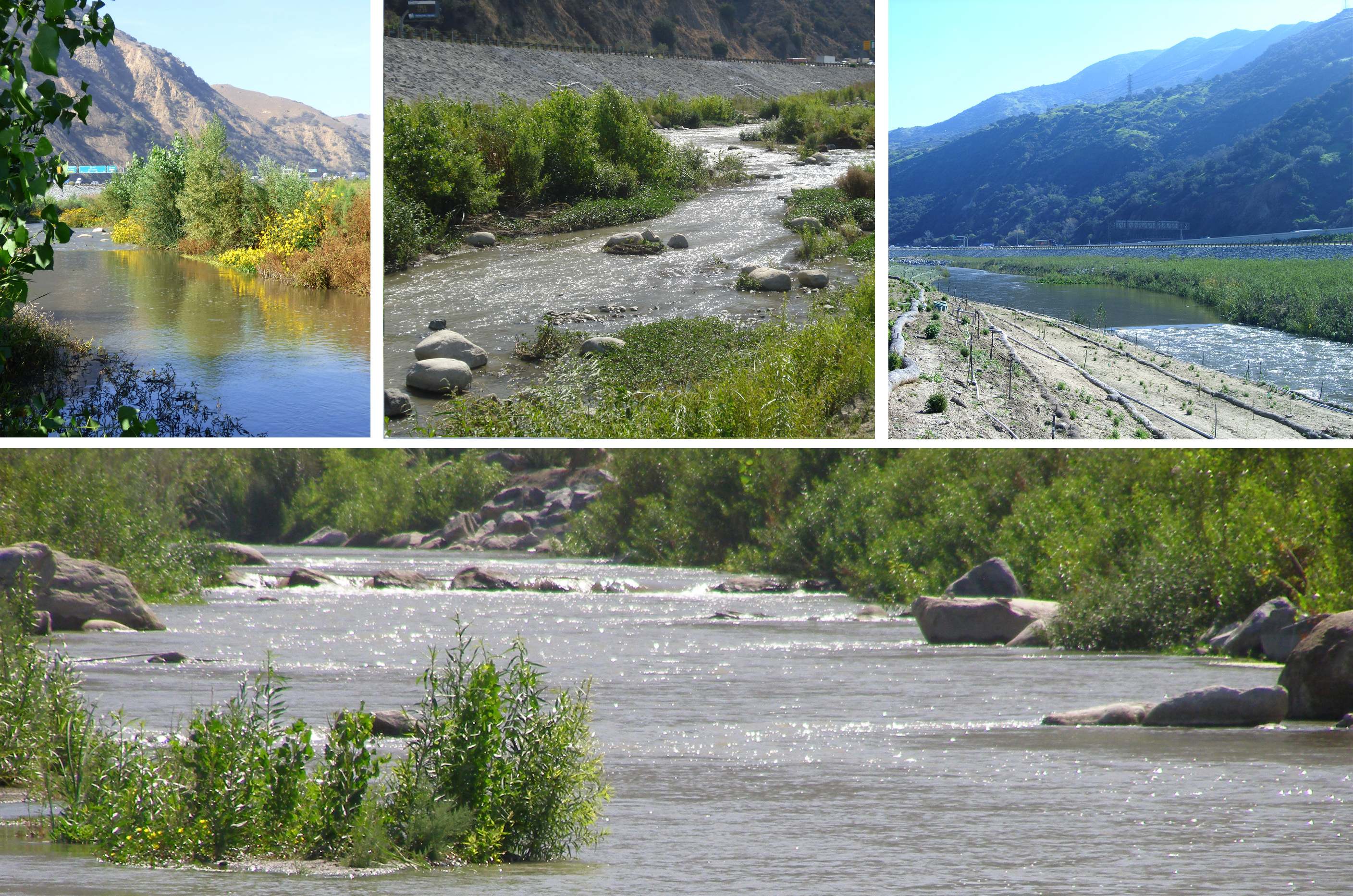 Image has been re-sized. Click for original size. |
| Project Description: | Project History and Timeline: Prior to the Perennial Stream Restoration project, the south bank grouted riprap protection (close to Highway 91) was designed by the in-house staff of the Los Angeles District and construction was awarded to Harper Contracting, Inc., in 2009. This provided an opportunity for environmental restoration due to the temporary diversion of the river. An AE Services contract was awarded to WRC Consulting Services, Inc., in early 2010 for the design of environmental habitat restoration within the project boundaries bound by bank protection/Highway 91 and the golf course. This restoration project serves as environmental mitigation for the temporary and permanent loss of riparian and upland habitat due to construction within Reach 9 and other areas of SARM features. It provides stream environments and habitat appropriate to support the threatened Santa Ana sucker fish as well as riparian woodland habitat intended to support the endangered Least Bell’s vireo and other special-status birds. The Santa Ana sucker is a fish that was common in Santa Ana River streams prior to the 1970s but is now rarely found. Project Strategies and Details: Flood Risk Management. The flood protection measures include the south bank grouted stone bank protection to protect the highway and roadway infrastructures and plain riprap protection measures along the created meandering banks where soils are vulnerable to erosion by the river flood flow or lateral storm drain outflow (more than 15 laterals). The flood flow is a potential 30,000-cfs release from Prado Dam. The bank-full discharge is approximately 6,000 cfs, using the golf course as overflow when the flood exceeds this level. Environmental Restoration. Flows along the Perennial Stream Project average a daily flow of 125 cfs during the non-flood season. To create a perennial stream habitat suitable for the Santa Ana Sucker fish, the following features were included: • Understory native plants were planted within the Black Willow and Arroyo Willow communities to help stabilize the ground. Other features of the project included: Results Plant monitoring started in 2012 one year after the first phase of construction and monitoring of the stream began in 2013 after major construction completion. The monitoring results are encouraging. Along with the installed vegetation, an impressive number of other native riparian plant species have naturally colonized into the project area. The density and diversity of the establishing vegetation suggests a high potential for this project to meet the following ultimate restoration goals: The channel banks have experienced minimal storm flows since they were constructed and show signs of successfully withstanding erosion from flows up to a 450-cfs release from Prado Dam. Areas with dense vegetation showed signs of very minor erosion, while the recently planted areas sustained the expected minimal damage. The banks edges show signs of naturally stabilizing themselves as the vegetation continues to mature. Replication The Lower Santa Ana River Reach 9 Phase 2B Project has a high potential for replication among other natural stream restoration projects. The naturalistic grading of the channel side slopes provides greater habitat diversity by creating planting terraces at varying elevations. For example, plant species like Black Willow can be placed on terraces close to the low flow invert of the river, allowing for periodic inundation with water. Other riparian plant species like Arroyo Willow and Western Sycamore trees can be placed on terraces set at slightly higher elevations where less-frequent inundation areas are beneficial for their establishment. Creation of the perennial stream habitat itself serves as an example of how habitat restoration can be accomplished in channels that have been highly modified from their natural condition. Modifications to traditional pool and riffle design were necessitated by constraints from protecting structures and land uses. The shallow-flow areas were created to widen the river bottom and simulate “pool” conditions without deepening the riverbed. The narrow section reaches were designed to produce “riffle” conditions without steepening the river bottom. Combining the low-flow meander pattern and varying channel geometry allows the river to restore its ecological diversity. The channel geometry ensures that diversified flow velocities are present in support of Santa Ana sucker fish habitats.
|
| Project Justification: | Many stream restoration projects have been planned, designed, constructed and monitored in Southern California since 2000. The Santa Ana River stream restoration projects constructed along the Green River Golf Course in Orange County, however, is unique in terms of its features, technical challenges, and project coordination and permitting efficiency. The project has been nominated for an engineering award, as it involves comprehensive engineering planning, analysis, design and construction to provide backbone support beneficial for successful habitat establishment as well as needed protection for critical infrastructures.
|
| Special Circumstances: | This project has bonded the team members including USACE staff, construction group, engineers, and biologists. We continued to observe and monitor restoration progress. A true partnership has been developed based on our common passions for restoration in the Santa Ana River. It has been a joy for us to see the plant growth and water splashing over the boulders. We shared notes and discussed areas of improvements. The relationship and passion will definitely benefit the project as habitats are establishing along the way. |
| Project Attachments: | Habitat Restoration |
| Award Citation: | A natural stream was successfully re-created along the Santa Ana River near the Green River Golf Course. Featuring the Santa Ana sucker fish and a riparian community, the project involved major design and construction challenges in order to overcome unfavorable pre-project conditions. To date, pools, riffles, river bends, gravel bars and riparian plants have been established; one may no longer recognize that this habitat sanctuary was once a typical urban concrete drain. |
| Suggested Award Summary: | The Santa Ana River Perennial Stream Restoration Project is located within a one mile long flood control channel surrounding the Green River Golf Course. Unlike many other restoration projects, this project highlights an endangered species—the Santa Ana sucker fish—in addition to facilitating riparian planting. It is highly dependent on its civil engineering design to create a natural meandering stream with special fishery features within a confined space between the golf course and Highway 91. The natural stream features include pools, riffles, river bends, gravel beds, sandbars, terraced inverts and banks, and shading trees and stones. Through a rigorous planning process for goal -setting, scoping, and approach definition, a concept plan was derived by the USACE consultant team (WRC Consulting Services, Inc., and San Marino Environmental Associates, Inc.) and approved by stakeholders ( U.S. Army Corps of Engineers, Orange County Public Works, the Orange County Green River Golf Course, California State Parks, the California Department of Fish and Game, and other regulatory agencies). Many talents have been drawn upon to overcome unfavorable pre-project conditions and the conflicting objectives such as structural stability for flood and erosion control versus preservation of the natural setting for the Santa Ana sucker fish and the riparian wetlands. A comprehensive design process was undertaken to detail survey control, grading, utility relocation, rock placement, erosion control, landscaping, irrigation, flow-diversion, construction phasing, and the other special features stated above. Detailed two-dimensional hydraulic modeling of the created channel under various flow conditions was performed to provide erosion-control guidelines and to confirm the flood control function and verify overall creek stability. This project component was added during the construction of the south bank protection. To reduce the reconstruction costs, design analysis, final design, and preparation of construction plans and specifications were expedited under close coordination with Harper Contracting, Inc. , Inc. USACE Construction Contractor. Regulatory agencies participated in every phase of project, and comment resolution was timely incorporated for project approval. The project has been successfully constructed following strategized phases for earthwork, rock placement, lateral drain placement, flow diversion, seeding and planting. A program for monitoring the performance of special design features and plant growth was developed and has been implemented following each phase of construction. |
Additional Information
| Additional Information: | None |
| Additional Files: |